ვარნეთი – მაღალმთიანი ზონის მრავალფენიანი აგროპასტორალური კომპლექსი სამცხე-ჯავახეთში
უილიამ ანდერსონი, მიშელ ნეგუს კლერი, ნიკოლოზ ცქვიტინიძესაქართველოს ეროვნული მუზეუმის მოამბე. ნომერი XI (57-B), გვ.11-30
სტატიის მიღების თარიღი: იანვარი, 2025 წელი
სტატიის გამოქვეყნების თარიღი: დეკემბერი, 2025 წელი
საკვანძო სიტყვები: ბრინჯაოს ხანა, რკინის ხანა, აგროპასტორალური საზოგადოება, სამცხე-ჯავახეთი
ვრცელი რეზუმე
ვარნეთის ნამოსახლარი მდებარეობს ასპინძის მუნიციპალიტეტში, სოფელ ერკოტას მახლობლად, ერუშეთის ქედზე, საიდანაც ის ჩრდილოეთის მიმართულებით მტკვრის ხეობას გადმოჰყურებს. სამხრეთიდან ვარნეთი გარშემორტყმულია მაღალმთიანი საძოვრებით. მის ზემოთ არსებულ ქედზე აღმოჩენილია სხვადასხვა პერიოდის არაერთი არქეოლოგიური ობიექტი – ადრებრინჯაოს ხანიდან შუა საუკუნეების ჩათვლით. დაფიქსირებული არქეოლოგიური ძეგლები ნათლად ასახავს ამ ტერიტორიის მნიშვნელოვან ეკონომიკურ და სტრატეგიულ როლს სამცხე-ჯავახეთის რეგიონში.
ვარნეთის ტერიტორიაზე არქეოლოგიური კვლევა 2013 წლიდან საერთაშორისო პროექტის „საქართველოს ლანდშაფტური არქეოლოგია“ (LAG) ფარგლებში ხორციელდება. მისი მიზანია ერუშეთის მაღალმთიანეთში უძველესი ნამოსახლარების, და ზოგადად ამ ტერიტორიის ადამიანის მიერ ათვისების ისტორიის შესწავლა (Anderson et al. 2014: 25–28; Anderson et al. 2019). საკვლევ არეალზე წარმოებული არქეოლოგიური სამუშაოების შედეგად გამოვლინდა კულტურული ფენები, ნაგებობათა ნაშთები, აგრეთვე სამეურნეო და თავდაცვითი მიზნით ძველი მოსახლეობის მიერ მიწის რელიეფის ცვლილების კვალი. რადიონახშირბადული ანალიზით დადასტურდა, რომ შესწავლილი ტერიტორია დასახლებული ყოფილა ძვ.წ. მე-3 ათასწლეულის ბოლოდან. არსებული მონაცემები ნათლად მიუთითებს ბრინჯაოს ხანისა და რკინის ხანის მნიშვნელოვანი ეტაპების არსებობაზე.
ვარნეთის პრეისტორიული კომპლექსის ძირითადი ნაწილი წარმოდგენილია ზედა ქედზე განლაგებული სამი ობიექტით:
ვარნეთი 1 – ადგილი, სადაც მეწყრული პროცესების შედეგად გაშიშვლდა შუაბრინჯაოს ხანის ფენები;
ვარნეთი 2 – გორაკი, სადაც მიწის ეროზიის შედეგად გამოვლინდა ადრებრინჯაოს ხანის კერამიკა და ქვის იარაღები;
ვარნეთი 4 – იგივე ვარნეთის თავკალო — ხელოვნურად მოსწორებული გორაკის თავი, სადაც ფიქსირდება ნაგებობათა ნაშთები და არტეფაქტები. აქ მოპოვებული მასალა ძირითადად გვიანბრინჯაო/რკინის ხანითა და ანტიკური პერიოდით თარიღდება.
ნამოსახლარი ძვ.წ. მე-2 საუკუნის დასაწყისში წყვეტს არსებობას. ტერასები, ქვით შემოღობილი ნაკვეთები და ბილიკები მიუთითებს, რომ ეს ტერიტორია მიწათმოქმედებისა და მესაქონლეობის აქტიური ადგილი იყო, რომელიც დაბლობში მდებარე მტკვრის ხეობასა და მაღალმთიან საძოვრებს (ადგილობრივ მოსახლეობაში „იაილას“ სახელით ცნობილს) ერთმანეთთან აკავშირებდა. ეს პროცესი გვიან შუა საუკუნეებამდე გრძელდებოდა, როდესაც ვარნეთისა და ერკოტას სოფლები არსებობდა.
ვარნეთის ნამოსახლარის ხასიათის განსაზღვრის შემდეგ, პროექტ LAG-ის კვლევის ერთ-ერთ მთავარ მიზნად იქცა აქ არსებული ნამოსახლარის და მისი მიმდებარე ტერიტორიის ფუნქციის შესწავლა – კერძოდ, როგორ ინარჩუნებდა ეს ტერიტორია თავის მნიშვნელობას ხანგრძლივი დროის განმავლობაში, მაშინ როდესაც უძველეს ეპოქაში ხალხთა გადაადგილების არაერთი შემთხვევა ფიქსირდება.
გამოვლენილ არქეოლოგიურ ობიექტებზე დაკვირვება გვაძლევს საფუძველს ვივარაუდოთ, რომ ვარნეთი რეგიონში მიწათმოქმედ და მესაქონლე საზოგადოებებს შორის დამაკავშირებელ რგოლს წარმოადგენდა, ან ერთგვარი „კარიბჭის“ როლს ასრულებდა, რომლის გავლითაც კონტროლდებოდა წვდომა, როგორც მტკვრის ხეობის, სამიწადმოქმედო საქმიანობისთვის ხელსაყრელ დაბლობზე, ისე მაღალმთიან საძოვრებზე (Anderson et al. 2019).
არქეოლოგიური მონაცემების დაგროვებამ კიდევ უფრო გამოკვეთა ძეგლის როლი და დანიშნულება. ვარნეთის კომპლექსის არქეოლოგიური ობიექტები სხვადასხვა რელიეფსა და სიმაღლეზე მდებარეობს და თითოეული მათგანი განსხვავებულ ქრონოლოგიურ ჩარჩოში თავსდება.
სტატიის მიზანია წარმოდგენილი იქნას ყველა ის კომპონენტი, რომელიც ვარნეთს ნამოსახლართა კომპლექსად ქმნის. აღწერილია მისი ძირითადი სამი ობიექტი, მათი ადგილმდებარეობისა და ტოპოგრაფიული მახასიათებლების ჩათვლით, აგრეთვე მოცემულია გამოყენებული კვლევის მეთოდები და მიღებული შედეგები.
დაკვირვებამ აჩვენა, რომ სხვადასხვა პერიოდის ობიექტები ერთმანეთთან ახლოს მდებარეობს და ზოგ შემთხვევაში ერთმანეთს ფარავს. დროთა განმავლობაში, გეოგრაფიული პროცესების ზეგავლენით, მათი ადგილმდებარეობა მცირედ იცვლებოდა, რაც ჰორიზონტალური სტრატიგრაფიის ჩამოყალიბებას განაპირობებდა.
Introduction
Varneti is an abandoned settlement located above the Mtkvari River valley near Aspindza, in Samtskhe-Javakheti province, in the east of the Erusheti Highland (Figure 1). This location overlooks the river valley and is within reach of the elevated pasture (yayla), at the interface of different topographic and ecological zones (Figure 2). On the ridge above Varneti village, numerous archaeological features dating from the Early and Middle Bronze Age, Iron Age, and medieval centuries show the enduring economic and strategic importance of this landscape position.
Archaeological surveys have been carried out in the locality of Varneti since 2013 as part of the Landscape Archaeology in Georgia (LAG) Project, a Georgian-international collaboration that investigates settlement and land use history in the Erusheti Highland (Anderson et al. 2014: 25–28; Anderson et al. 2019). Structural features, artefact deposits, and land modifications have been documented, and preliminary excavations have been undertaken. Radiocarbon dating proves occupation from the late-third millennium BC; these dates and other forms of evidence indicate important phases of occupation in the Early to Middle Bronze Age, Late Bronze Age, and Iron Age.
Three adjacent sites on the upper ridge form the core of the Varneti prehistoric complex: Varneti 1, where a landslip has exposed Middle Bronze Age deposits; Varneti 2, a hillock where artefacts eroding from ground include Early Bronze Age pottery and lithics; and Varneti 4, or Varneti Tavkalo, a flat hilltop where structures and artefacts date principally from the Late Bronze Age and Iron Age to Classical periods, and where occupation ended by the early 2nd century BC. Terraces, enclosures and trackways indicate this locality’s status as an agropastoral centre and a zone of transit between the river valley and the yayla, including into the medieval and post-medieval eras, when occupation centred on the settlements of Varneti and Erkota.
Having determined the multi-period nature of occupation at Varneti, the LAG Project’s research questions turned to the function and usage of these sites – why the overall location remained important for so long while its focus changed over time. The attributes of recorded sites and their context led to the theory that Varneti served as a nexus or gateway for the region’s agropastoral farming communities, where access between the valley floor and the elevated pasture was regulated, and whose shifting centre of gravity corresponded with short-term changes and long-term continuity in the district’s political and economic organisation (Anderson et al. 2019). As knowledge of the component sites at Varneti increased, an understanding of its diachronic functions and meanings has emerged.
Archaeological features at Varneti are located on a variety of landforms, at different elevations, and they date from multiple time periods. Here, we present the components that together make up this complex. The attributes of key sites and feature types are summarised with an account of their location and topography, and the methods and results of archaeological investigations. Sites dating from different ages are located close to each other and in some cases overlap, but there are subtle differences in the geospatial focus over time which has produced a horizontal stratigraphy (Figure 3). This shifting focus may indicate prevailing social, technological and economic conditions, and responses to environmental changes, and reflect short and medium-term priorities at the local and regional scale. Yet, the continued significance of the overall landscape position was maintained during more than four millennia of occupation.
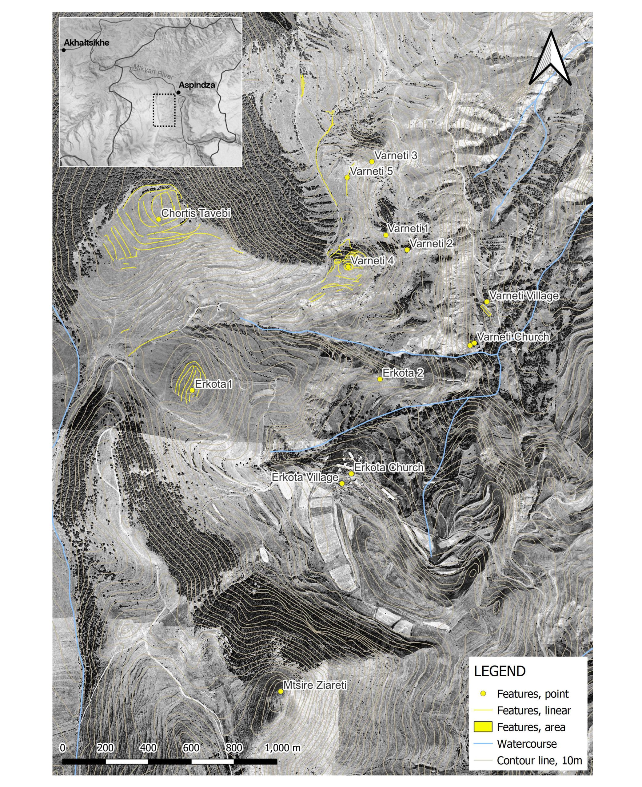
Figure 1. Map of Varneti and Erkota localities, with documented features
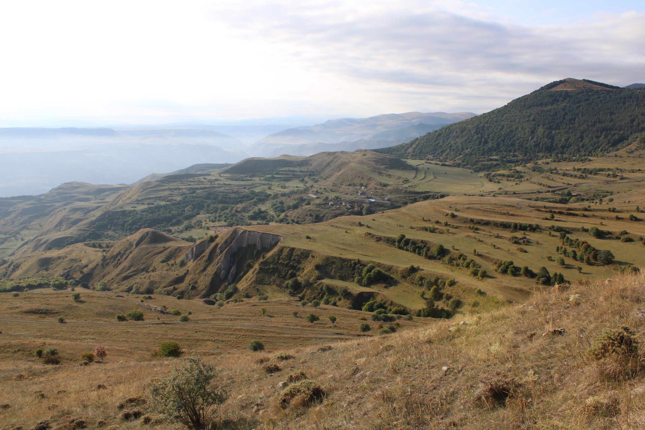
Figure 2. South-facing view from Varneti Tavkalo showing topographic gradation: the middle slopes of the Mtkvari valley on the left to the elevated valley and Erkota village in the centre, and Mtsire Ziareti the mountain on the right leading to the yayla.

Figure 3. The ridge above Varneti, facing northwest, with visible sites labelled.
Bronze Age occupation on the upper slopes (Varneti 1 and 2)
Varneti was first visited by the LAG Project team after a resident of nearby Sakudabeli village reported artefacts eroding from the steep upper slope of the valley. Part of a terrace had fallen away and exposed sediments along a profile 21 m in length and up to 4 m in height, which we have called Varneti 1 (Figure 4A). Ceramics, lithics and bone were contained within a stratum of pale brown silt starting at a depth of 0.5 m below the surface and in places more than 2 m thick, overlaying a dark grey horizon containing no artefacts, and below that stony colluvium. The profile was investigated by drawing and documenting its soil stratigraphy (Figure 4B), collecting exposed artefacts which were plotted on the section drawing, and gathering charcoal and bone samples for radiocarbon dating analysis.Ceramics were mostly large, thick-walled vessels with everted rims in gritty, mineral-tempered fabrics which are red to grey in section and with reddish brown to greyish brown to black exteriors (Figure 4C). Almost all were burnished, some highly polished and others with cursory, streaky burnishing that resemble late Kura-Araxes styles (Sagona 2000: 338–339). Finer, thin-walled sherds with pattern burnished lines and triangles are comparable to Bedeni products of the late-third millennium BC (Bedianashvili 2008: 89). Radiocarbon dating analysis of two charcoal and four bone samples returned calibrated ages within a 500-year window between the late third to mid-second millennium BC. The two charcoal samples returned ages of 2030–1530 cal BC while the four bone samples returned a narrower and later range of 1688–1416 cal BC (Anderson et al. 2019: 30).
The relatively flat ground behind the collapsed terrace may have been artificially levelled as an occupation area. The nature of the artefacts suggest a domestic deposit, a significant finding considering that most information on the Middle Bronze Age from the region derives from mortuary rather than settlement contexts (Gambashidze 1983; Licheli & Rusishvili 2008) and that the early second millennium is characterised by an abandonment of settled villages in favour of nomadic pastoralism (Smith 2012: 679–682). The identification of a Middle Bronze Age occupation area high on the valley sides supplements the results of ongoing excavations at Rabati in Zveli, 7 km from Varneti, which are generating information on the ‘overlapping cultural traditions’ of the later Kura-Araxes period and the subsequent Markopi, Bedeni and Trialeti cultures in the upper Mtkvari River valley (Bedianashvili et al. 2021). The style of artefacts at Varneti 1 suggest that Early Bronze Age craft traditions may have persisted into the mid-second millennium.
Directly southeast of Varneti 1 is a hillock with steep sides rising to a pyramidical summit (Varneti 2), reached along a track that runs north/south, crossing a stream, and rising on a ramped course to the base of the hillock. Its northern side is a short, steep slope covered in planted pine trees and the southern slopes are longer, falling to a rugged tract of hillocks. This hill’s south face has sparse vegetation and the ground is eroded and rocky up to the pointed summit (Figure 5A). No structural remains are evident, but ceramic and lithic artefacts are strewn on the surface of the upper slopes. A systematic point sampling survey found higher densities of artefacts on the hilltop and upper slopes than the middle and lower slopes, showing that artefacts were eroding from in situ deposits near the summit (Anderson et al. 2019: 29); on the north slope ceramics were eroding from the tree roots and animal burrows. Inspection of other hillocks to the south found no artefacts on their equivalent, south-facing slopes, indicating Varneti 2 to be a distinctive locus of occupation.
Artefacts collected from Varneti 2 included diverse ceramics, mostly thick-walled, burnished vessels of later Kura-Araxes styles. Other Early Bronze Age ceramics were jars of fine and sandy fabric with polished black and red surfaces. Lithic artefacts make up 7% of systematically recorded surface artefacts, including obsidian scrapers and a flint biface sickle (Figure 5B). These stone tools also indicate the prevalence of Early Bronze Age deposits, however, a notable proportion of analysed ceramics were Early Iron Age wares in dark grey, gritty and coarse fabrics, some decorated ceramics with incised and impressed markings and finer grey and black wares that may date from the late second to early first millennium (Sagona 2012: 257–258). Together, the context and components of this assemblage suggest that Varneti 2 contains predominantly Early Bronze Age and Early Iron Age deposits.

Figure 4. Varneti 1. A – West-facing view of the profile; B – Scale drawing of the profile
with collection points and contexts; C –Early to Middle Bronze Age ceramics, examples
collected from the profile.
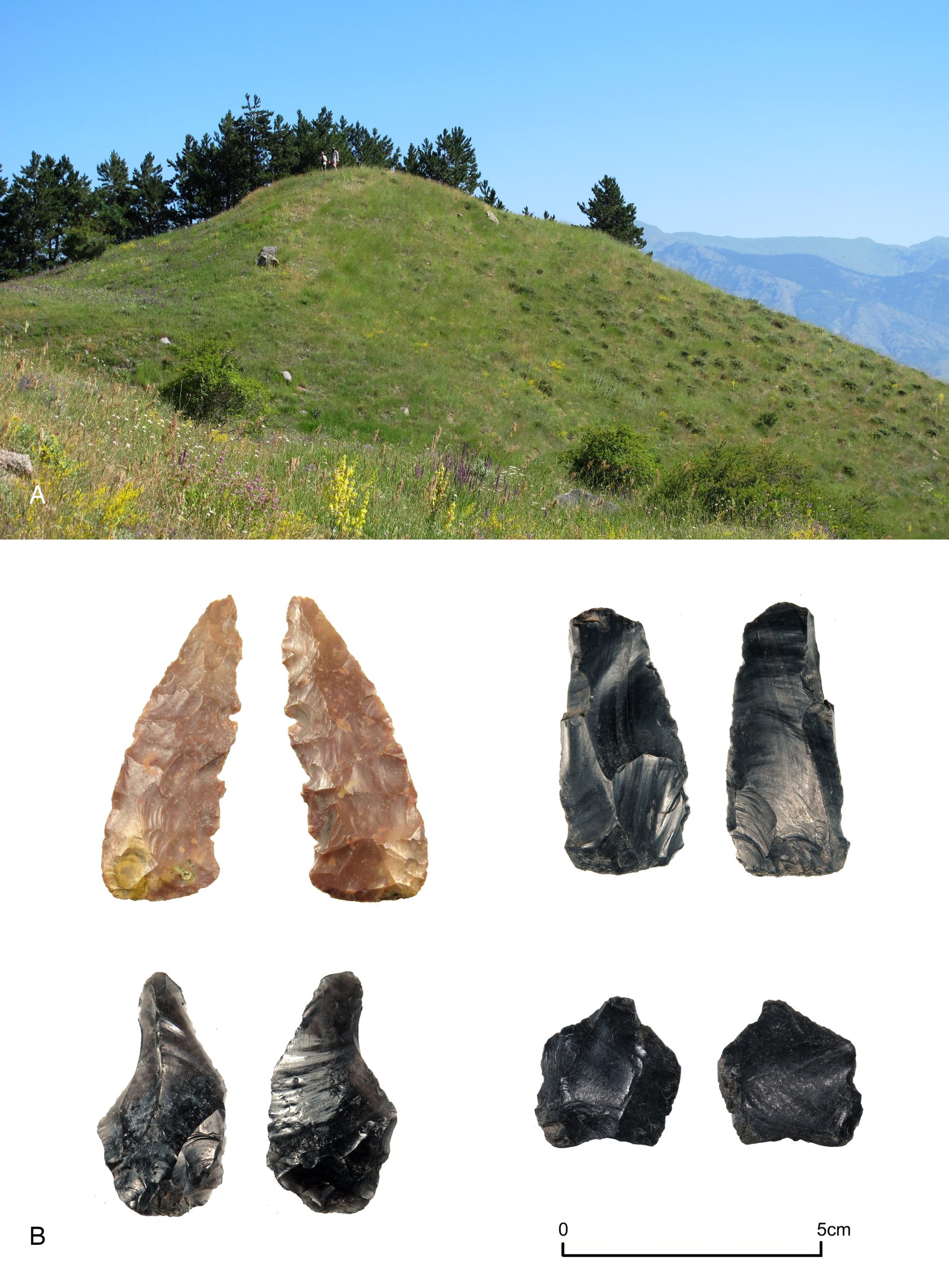
Figure 5. Varneti 2. A – North-facing view of the hillock; B – Flint and obsidian lithic tools, examples collected from the surface of Varneti 2.
Varneti Tavkalo, an Iron Age hilltop site (Varneti 4)
Varneti 1 and Varneti 2 appear to have been occupation areas that date from approximately the fourth to mid-second millennia BC. On the nearby summit of Varneti Tavkalo (Varneti 4), there are also indications of Early Bronze Age occupation, but more substantial are late Bronze Age and Iron Age remains, especially from the later first millennium BC. Tavkalo, meaning flat-topped hill, is a prominent landform whose summit (elevation: 1650 m), is oval-shaped in plan and covers an area of 1100 m2 with a maximum east/west diameter of 42 m, and has been modified through levelling and cuts into the natural rock (Figure 6A). The hilltop appeared to have been enclosed by a circuit wall and extensive scatters of pottery and tile were strewn across the hill’s upper south slope.Surface artefact survey recorded large amounts of pottery on the hill’s upper slopes and summit (Anderson et al. 2019: 32–33). The assemblage differed to that on the equivalent, southern slope of Varneti 2: Late Bronze Age ceramics were present, there was a smaller proportion of Early to Middle Bronze Age artefacts, and fewer lithic artefacts. Excavations later revealed Iron Age deposits and unearthed ceramic types that were not present in other parts of Varneti such as black polished grey ware (Figure 6B). Also noted were the remains of structural features, particularly accumulations of stone around the crest of the summit which were thought to be a circuit wall. This led to the characterisation of this summit as a hillfort, however, the identification of this wall as having a fortified or defensive purpose was found to be mistaken: the initial impression of a Late Bronze Age fort that was re-built in the medieval period was disproved by the results of excavations.
Varneti Tavkalo was the main target for archaeological test excavations in 2019 (Chkhvimiani et al. 2020). We therefore have a finer-grained level of information for this location than for other parts of Varneti. The results of these excavations, whose full publication is forthcoming, was to uncover significant deposits on the hilltop, including well-preserved structural remains which demonstrate a substantial occupation that spanned the Late Bronze Age and Iron Age to Classical periods. Of particular note was a partially subterranean, two-storey building with flagstone floors set into the cut bedrock that appears to have been destroyed at a time no later than the early 2nd century BC. Part of a sunken room with plastered walls and a wooden bench around its side was excavated, which was in use after c.1200 BC and was destroyed in a fire in c. 4th-early 2nd century BC, based on radiocarbon dating. Following this event, the hilltop appears to have been abandoned for several centuries. The site was likely plundered for building materials in the medieval period, at which time it was converted into a livestock enclosure, which was the purpose of the circuit wall – more a fence than a fortification. Further excavations at Varneti Tavkalo will enhance our understanding of Iron Age agropastoral societies in the southern Caucasus highlands.
0
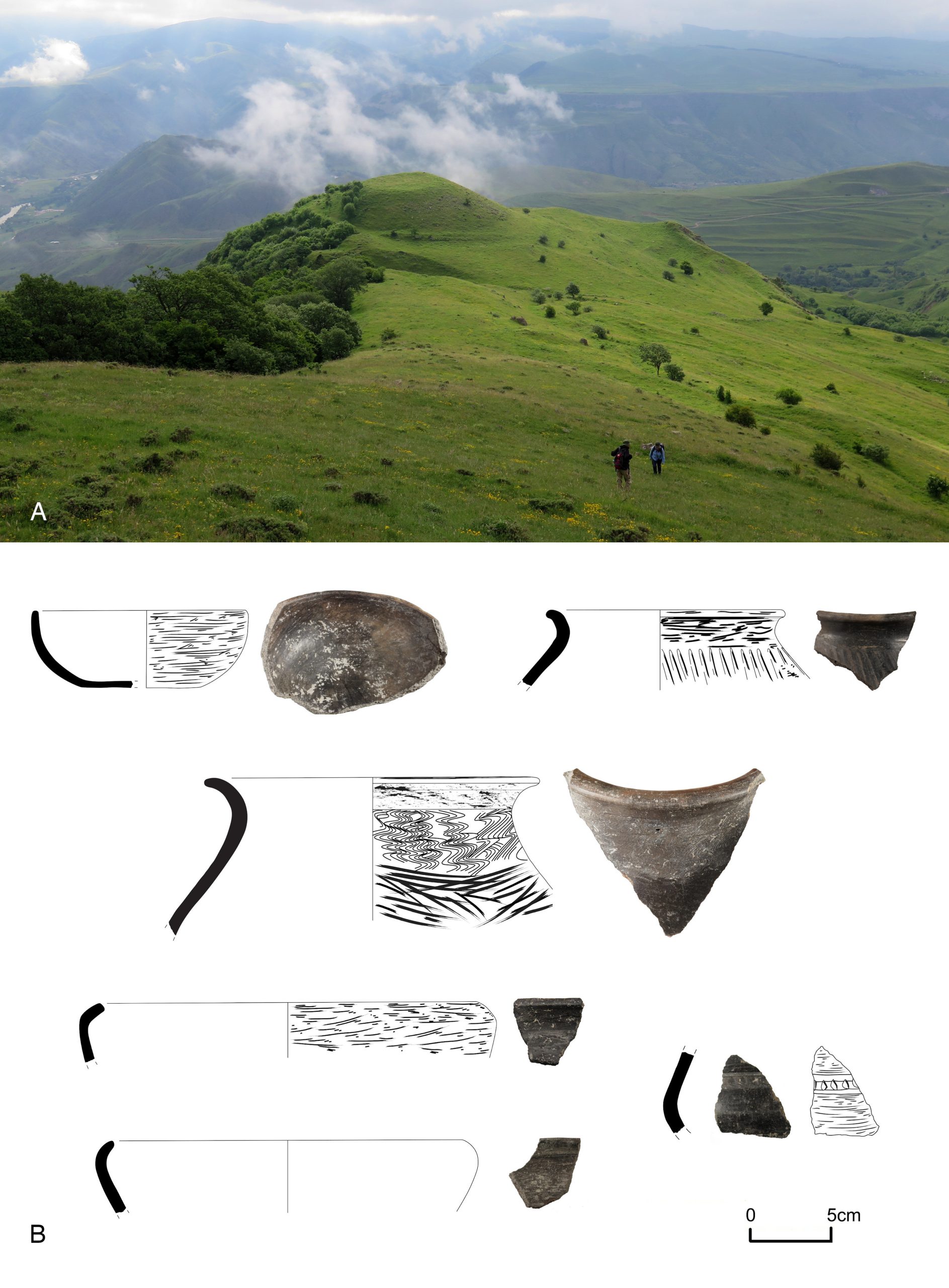
Figure 6. Varneti 4. A – east-facing view of Varneti Tavkalo from Chortis Tavebi; B – Black-polished grey ware vessels, a frequently occurring ceramic type excavated from Late Iron Age contexts on the hilltop.
Trackways – horizontal and vertical movement
People and animals moved between different locales at Varneti, and between settlements in the valley and the elevated yayla, along routeways which facilitated farming and occupation. Analyses of maps and aerial photographs, followed by ground survey, were used to trace potential ancient tracks and better understand axes of movement at the local scale within the Varneti locality and at the wider scale of horizontal and vertical routeways across the district. Ancient tracks are often sunken below the surrounding ground and are lined by drystone walls. They have formed into hollow ways through their repeated usage and the erosion caused by water channelled along them. Tracks connecting with the elevated yayla may be characterised as drove roads, along which livestock was herded, and these often run directly uphill, perpendicular to the slope, although the precipitous cliffs towards the top of the valley preclude the most direct route. Access to the upper locales of Varneti was determined by the topography, with identified tracks running along the saddle and gentler slopes to the north of Tavkalo, bypassing the cliffs to the east and south. Although dating the formation and usage of these tracks is approximate, their age may be estimated in relation to adjacent or intersected features. Trackways of ancient origin are usually sunken, however, one extrusive feature at Varneti is a raised linear embankment that forms a 2 m-high causeway (Varneti 5) that runs in a wide arc north of Tavkalo towards another hill (Varneti 3) (Figure 7A). A test pit was excavated on top of the causeway to learn whether this was an ancient feature and to investigate its construction, function and age. The pit was positioned between two prominent edging stones that frame the track traversing the top of the causeway. Beneath three distinctive soil strata was densely packed stone containing small pottery and bone inclusions (at 280 mm depth), which was recognised to be a cobbled surface which sits on a compacted layer of silt below which (at 700 mm depth) a second cobbled surface was revealed. Charcoal sampled from between the two cobbled surfaces returned a radiocarbon age of 1909 ± 18, calibrated to AD 57–130. The sample likely relates to the causeway’s usage rather than its construction, which likely dates from before the 1st century AD.The excavation confirmed the causeway to be an ancient feature and the identification of overlaying cobbled surfaces suggested sequential phases of construction and use. The compacted silt stratum between these surfaces suggested that there was a considerable timespan separating their construction. Whether routeways at Varneti were established formally or developed more organically is hard to determine. While planning and coordination would have been involved in building the causeway, other routes appear to have been established through an accretive process where maintenance was undertaken informally. The test excavation at the causeway indicates the recurrent usage of this ridgeway, and shows that its construction and upkeep were organised and planned.
Enclosures, corrals and pens pastoral infrastructure
Numerous drystone wall enclosures were documented to the north and east of Varneti Tavkalo and on the hill’s middle slope and summit. Enclosures of different size and shape are also present further downslope, and in the wider district are particularly prevalent on the yayla. Two enclosures in the north of Varneti are sub-rectangular in plan and formed by a series of walls adjoined to the main tracks leading north towards Sakudabeli and northeast, downslope towards Aspindza (Figure 7B). Another rectilinear enclosure is situated at the north base of the summit area of Varneti Tavkalo; as discussed, a circuit wall encloses the summit itself. The excavation of trenches that bisected the circuit wall on Varneti Tavkalo found that accumulations of stone around the crest of the hilltop to be an uncoursed and informally constructed wall without foundations that overlayed and long post-dated the Iron Age occupation remains. The wall was likely built to corral animals on the higher, well-drained ground.Enclosures built on the yayla above Varneti take various forms – circular, subcircular, squared and open-ended or horseshoe-shaped. Smaller enclosures are still in use today, usually situated beside seasonally occupied pastoral camps. As the location of such camps tends to move in the medium to long term, enclosures could be abandoned and new ones formed or older ones renovated and reused. The intensive usage of the yayla in the past – especially in the medieval and post-medieval periods when pastoralism in the region was at its peak (Maisuradze and Khardziani 2022) when whole villages decamped to temporary settlements, might explain the high concentration of these features beside abandoned pastoral camps. This indicates the intensity of pastoral farming during the mid-first to mid-second millennium AD. If Varneti served as a hub for pastoral activity, perhaps a staging post or a distribution point for livestock, this would explain the positioning of enclosures directly beside routeways, as holding pens for animals moving up to the yayla or down to the valley.
Agricultural terraces – cultivation at altitude
Hillsides on the middle and upper slopes of the Mtkvari River valley have been extensively modified into agricultural terraces (Figure 7C). Many of these features were likely constructed in the Late Bronze Age-Iron Age and the medieval period; there are also recent terraces that were made using machinery in the 20th century. Terraces were built to provide level ground for cultivation, retain soil and allow controlled irrigation, but they could also form incidentally as the result of repeated ploughing. Terraced hillsides indicate the importance of arable farming at higher elevations and signify the nature and scale of cultivation.Various morphological types of terrace are present in the surroundings of Varneti, but three general types of terrace are easily distinguished. First are manually built terraces to prevent slippage of soil downslope, which take the form of long curves following the natural contour of the slope, tapering off at each end, and resulting in distinctive, elongated field boundaries. Second are shallow terraces accumulated from the repeated upturning of ploughed soil, known in Britain as ‘lynchets’. Third are more recent terraces that were produced by mechanically grading and benching the slope using bulldozers, many likely deriving from Soviet agricultural practices to expand cultivatable land during the 20th century.
Determining the date that terraced agriculture began in the Varneti district is complicated due to the repeated usage of the land. Studies of terracing in the northern Caucasus Kislovodsk basin found an association of two distinct terrace types to occupation dating from the Late Bronze Age and early medieval periods respectively (Korobov and Borisov 2013); closer to Varneti, terraced hillsides in Javakheti appear to correspond with Late Bronze-Early Iron Age sites (Neumann et al. 2018). This might serve as a guide for the chronology of terraces around Varneti. However, aside from their antiquity, they are significant for showing that terraced agriculture involved cultivation on marginal land at high elevations, and reflecting high rural population levels expanding and diversifying their farming practices.
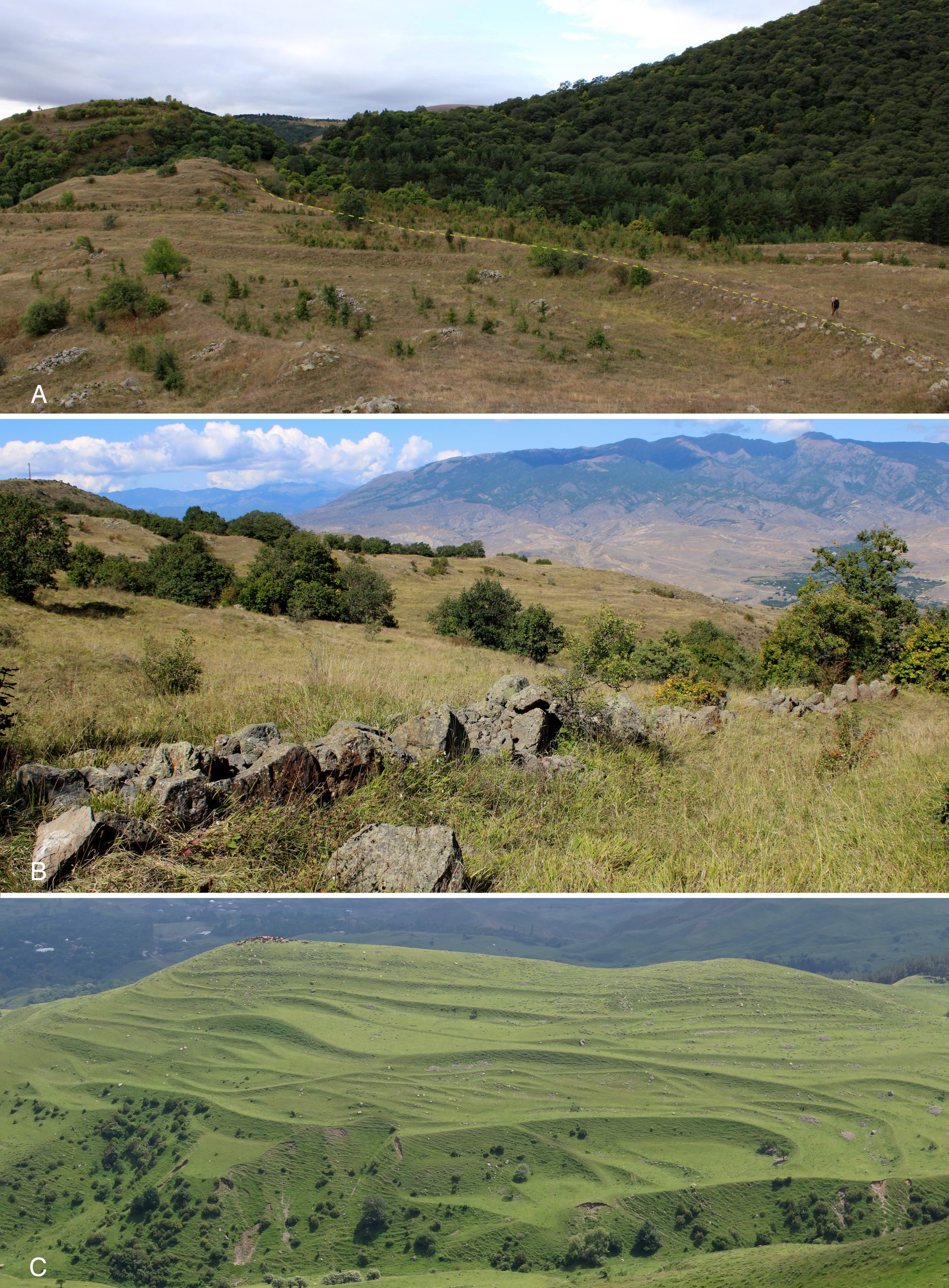
Figure 7. A – Varneti 5, the raised causeway north of Varneti Tavkalo, south-facing view with the edge of the causeway marked in yellow dashes; B – Enclosure wall beside trackway north of Varneti 3; C – Terraces to the southeast of Varneti, including manually built terraces and lynchets.
Varneti settlement
Nestled in a hollow below the main ridgeline is Varneti village, located 650 m to the southeast of Varneti Tavkalo and more than 250 m lower in elevation. The outlines of ruined buildings visible on aerial photos show that the settlement spanned an area of approximately seven hectares along the base of the cliffs. Today, Varneti is uninhabited, the area is thickly overgrown, and only a handful of cultivation plots are tended. A disused, Soviet-era barn may have been the final structure built here. The humid and sheltered aspect of the location was advantageous, but it may have contributed to the settlement’s demise – an outbreak of malaria is said to have led to its abandonment in the second half of the 20th century. Ottoman taxation documents show that Varneti was flourishing in the later 16th century: there were 13 male landowners based here whose holdings included 400 sheep, 100 hogs and 50 beehives, and barley and wheat were cultivated, making this a medium-sized settlement in relation to other villages in the region (Negus Cleary et al. 2018).On a bluff projecting from the cliff face, a ruined but partially standing church with associated buildings is Varneti’s most prominent archaeological feature. Only the apse end of the church is intact, perched on the eroding ledge and at risk of imminent collapse (Figure 8A). This was once a substantial and richly decorated church built of basalt with dressed sandstone facing; repairs to the walls incorporate tiles that may have derived from the nearby Iron Age complex on Varneti Tavkalo. The standing east end is comprised of a two-storey structure with a lower crypt area, supporting a semi-circular apse and half dome with three round arched windows (Figure 8C). Portions of the dome bear fragments of wall plaster with remnants of crimson painted fresco and two ‘acoustic jars’ are set into the dome (Figure 8D).
Other built features beside the church include a wall enclosing the north and south sides of the bluff (Figure 8B), a cistern and a square plan building on a platform west of the church. This was not an isolated church but an enclosed complex of buildings, although they might have been constructed sequentially rather than as part of a single scheme. One indication of post-medieval activity is a finely carved stone Ottoman grave marker, though whether it originates from this exact location is unknown.
This elevated landform would have had a strategic quality as it offers a vantage point overlooking the key communications route along the Mtkvari River valley, but with a lower and more limited viewshed than Varneti Tavkalo. The wall enclosing the summit may indicate that the bluff had a fortified character, which has been said of this church (Gverdtsiteli 1979). Alternatively, the enclosed church buildings located on a high bluff, slightly removed from the village, is reminiscent of a monastic complex, in a context similar to the monasteries at nearby Kheoti and Agara on the Uraveli River valley. The wall around the complex may have been to demarcate the sacred land and protect the seclusion of the monks. Enclosing walls are a feature of medieval churches in many villages in the elevated valleys above the Mtkvari River, including at Chobareti Verana, Zveli and Erkota (Anderson et al. 2014: 20–21). In addition, Licheli et al. (2020) consider the medieval tradition in Samtskhe-Javakheti of constructing monastic complexes within prehistoric cyclopean fortifications in order to utilise the walls to enclose the churches. Although there are not indications of prehistoric occupation on the bluff above Varneti village, the enclosure of an ecclesiastical or monastic complex on a prominent landform close to a village is characteristic of the region’s medieval settlement pattern.
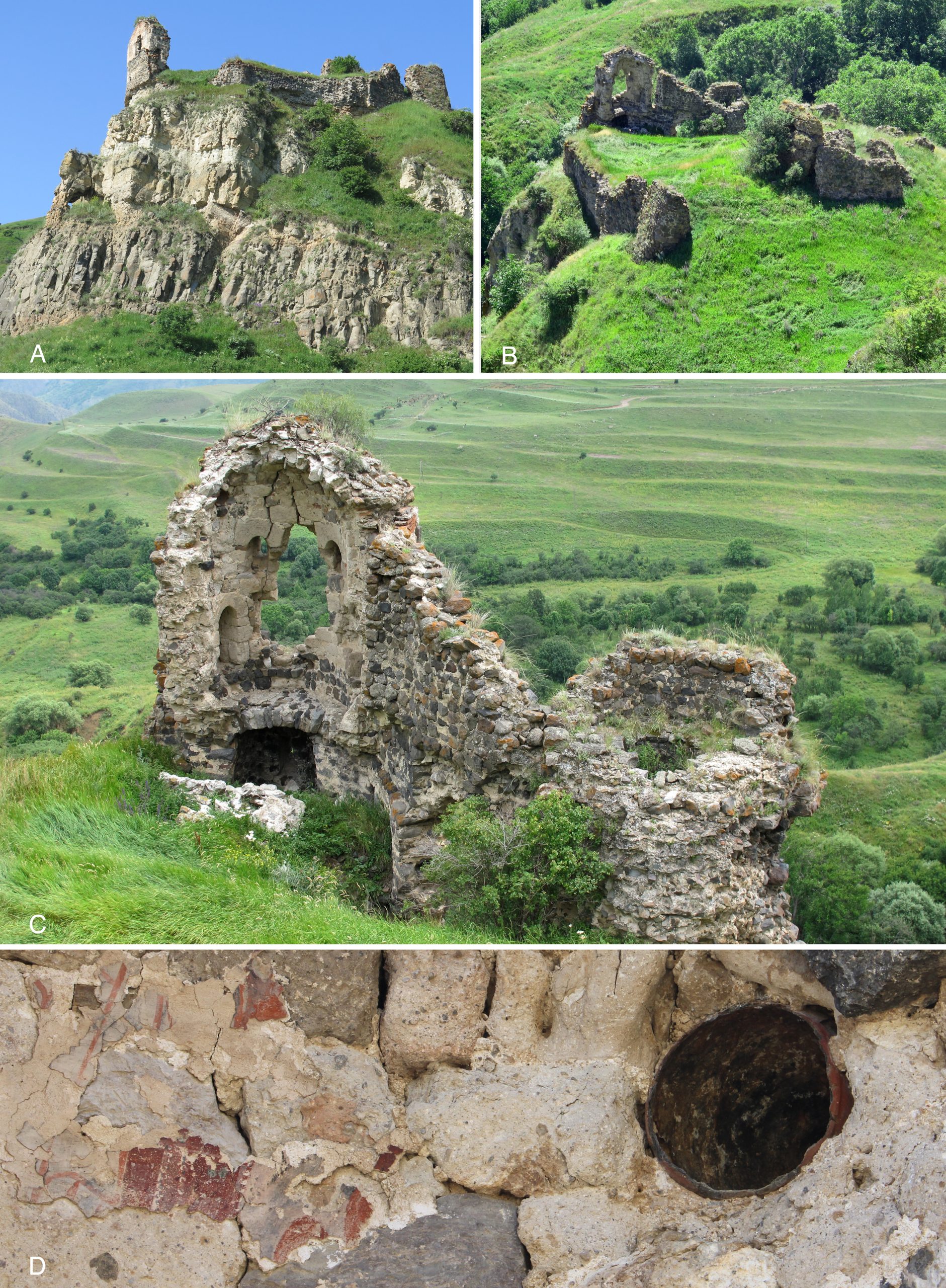
Figure 8. Varneti Church. A – South-facing view to Varneti Church; B – East-facing view of Varneti Church; C –Varneti Church apse, east-facing view; D – Detail of apse dome showing traces of fresco and an acoustic jar.
Erkota settlement
Erkota, located 1 km south of Varneti at the foot of Mtsire Ziareti, is today a loose grouping of barns among the ruins of what was once a larger but still modestly sized settlement. Though its population is diminished, Erkota was also included in the late-16th century Ottoman registers. The dilapidated church incorporates elements that show it was established during the medieval period. Surrounding the village are remains that attest to the area’s longer-term occupation, which relates to its position immediately below a pass that provides access to the elevated yayla. The church is heavily reconstructed in a vernacular fashion, sitting upon a basalt platform and formed of diverse masonry elements that likely derive from an earlier structure (Figure 9A). A detached bell tower west of the church bears the date 1916, when the last rebuilding presumably took place. The modest, single nave plan church has a dressed basalt mortared exterior and plaster coating and its roof is barrel vaulted. Two carved stones are built into the exterior of the west front – a lintel with two Bolnisi crosses and on the north side doorway post a stone with a cross and floral ‘wings’ which has been installed upside down. Inside, a large font is comprised of a drum supporting a heavy square stone with a cross carved on top (Figure 9B). In the small enclosed churchyard is a scattering of gravestones including one in the shape of a ram which has decoration carved on both of its flanks – a pair of shears on one side, and on the other a human figure holding two oblong objects that may be threshing sledges (Figure 9C). This is one of more than two dozen ram-shaped gravestones documented within the LAG Project’s survey area, examples of a long-running medieval and post-medieval sculptural tradition in parts of southern Caucasia, eastern Anatolia and northwest Iran (Anderson 2023).Erkota may have served as a stopping place en route to the yayla, and its long-term use by pastoral communities is suggested by a drove road and possible occupation areas on surrounding hills. Two hills surveyed in the immediate vicinity of Erkota had cultural features present on the surface. To the west of Erkota is a low, elongated hill with terraced sides where the flat top, which is a thin lozenge shape, spans an area of 0.4 hectares (Erkota 1) (Figure 9D). This hill marks the crest of the Mtkvari River valley, and to the west a stream valley leads up to the yayla. The hill appears to be encircled by a wall, the remains of which are indistinct and not monumental enough to be confirmed as a ‘cyclopean fortress’, although this site has been characterised as a ‘fortified settlement’ (Narimanishvili 2019: 192). Instead, the wall may have been a large enclosure with incorporated farmstead; whether its usage was primarily agricultural or martial, it would have offered strategic advantages. On a steep, rounded double hill north of Erkota village (Erkota 2), the higher of which is accessed along a thin saddle, several wall lines were noted and a thin scatter of ceramic sherds were collected from the upper, south-facing slope (Figure 9E). This may also be a hilltop occupation area, comparable with Varneti 2, showing the preference for Early Bronze Age settlement of steep, high slopes.
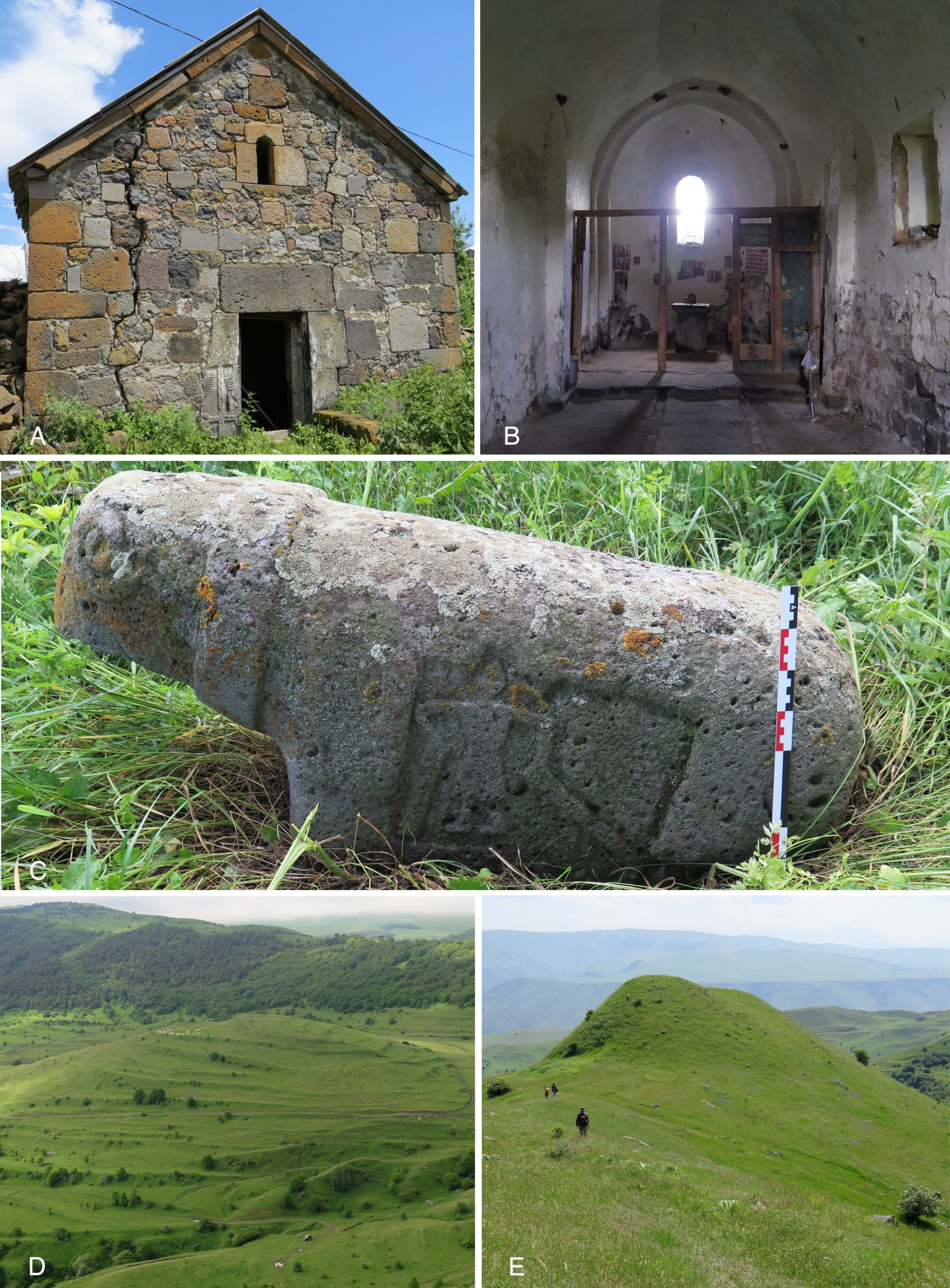
Figure 9. Erkota. A – Erkora Church west front with carved decorated stone set into doorway; B – Erkota Church interior, facing east; C – Ram-shaped gravestone in Erkota churchyard; D – Erkota 1, south-facing view; E – Erkota 2, east-facing view.
Conclusion
In the above summaries we have sketched an outline of the key elements that form what we characterise – as a term of convenience – the Varneti complex of archaeological sites. These remains have accumulated over a period of more than four millennia, from the late third/early second millennium BC (although probably earlier) to the present day. While certain phases stand out as having more intensive occupation, the presence of Bronze Age, Iron Age and Classical to medieval remains indicate that this landscape position’s importance persisted through differing environmental, economic and social climates.On the hillock of Varneti 2 are deposits dating from the fourth to third millennium BC while the exposed profile of Varneti 1 appears to be an occupation area of the early-mid second millennium BC. Varneti 4, the flat-topped hill of Varneti Tavkalo, also contains Bronze Age remains, but more prominent are the Iron Age features that date up to the 4th – early 2nd century BC, which was the latest major phase of occupation. A test excavation on Varneti 5, the causeway connecting Tavkalo Varneti with the hill of Varneti 3 to the north, returned a radiocarbon date of the 1st century AD, however, this ridgeway may have been used as a route of horizontal movement from earlier times. Varneti and Erkota were part of a wide-ranging network of closely spaced settlements which indicate a flourishing agropastoral society that operated in the medieval and post-medieval centuries. Land modifications relating to arable (terraces) and pastoral farming (enclosures and drove roads) likely date from these periods, and these features have continued or have been modified for use in the contemporary farming economy.
The separation of archaeological sites at Varneti is somewhat artificial: the individual sites that make up this complex – the Early-Middle Bronze deposits at Varneti 1, the hilltop Iron Age complex at Varneti 4 and the medieval ecclesiastical complex above Varneti village – have significance in and of themselves. Yet, it is their spatial and temporal interrelation and the perennial importance of this locale through millennia that underlines its true significance. Varneti as a whole is more than the sum of its parts. Being a pivotal point between the river valley and yayla, investigations at Varneti help us to understand spatial interaction, movement and social and economic organisation through time.
Acknowledgement
We thank Kakha Kakhiani and Giorgi Bedianashvili, who have facilitated our investigations at Varneti over the years. We thank our fellow LAG Project team members Damjan Krsmanovic, Giorgi Chilingarashvili, Madona Mshvildadze and Jessie Birkett-Rees, as well as Jimsher Chkhvimiani and Giorgi Gogoladze.Refereces:
Anderson, W. 2023. How gravestones shaped as sheep united the Caucasus. Sapiens Anthropology Magazine. https://www.sapiens.org/archaeology/gravestones-caucasus/
Anderson, W., Birkett-Rees, J., Negus Cleary, M., Krsmanovic, D., & Tskvitinidze, N. 2014. Archaeological survey in the South Caucasus (Samtskhe-Javakheti, Georgia): Approaches, methods and first results. Anatolia Antiqua 22: 11–33.
Anderson, W., Negus Cleary, M., Birkett-Rees, J., Krsmanovic, D., & Tskvitinidze, N. 2019. Gateway to the yayla: The Varneti archaeological complex in the southern Caucasus highlands. European Journal of Archaeology 22(1): 22–43.
Bedianashvili, G. 2008. Pattern-burnished ornament in Georgia during the Bronze Age. In: K. S. Rubinson & A. Sagona (Eds.), Ceramics in Transitions. Chalcolithic through Iron Age in the Highlands of the Southern Caucasus and Anatolia (pp. 87–100). Ancient Near Eastern Studies Supplement 27. Leuven: Peeters.
Bedianashvili, G., Sagona, C., Longford, C., & Martkoplishvili, I. 2019. Archaeological investigations at the multi-period settlement of Rabati, southwest Georgia: preliminary report (2016, 2018 seasons). Ancient Near Eastern Studies 56: 1–133.
Bedianashvili, G., Jamieson, A., & Sagona, C. 2021. The Early Kurgan Period in Rabati, Georgia: The cultural sequence and a new suite of radiocarbon dates. Radiocarbon 63(6): 1673–1713.
Chkhvimiani, J., Anderson, W., Negus Cleary, M., & Krsmanovic, D. 2020. A short report of archaeological excavations at Varneti (Aspindza municipality, Samtskhe-Javakheti) in 2019. In: M. Cholokashvili & T. Niniashvili (Eds.), Collection of Short Reports of Archaeological Excavations Conducted in 2019 (pp. 397–403). Tbilisi: National Agency for Cultural Heritage Preservation of Georgia.
Gambashidze, O. 1983. Concerning the Materials of the Asia Minor-Aegean World in Samtskhe-Saatabago (in Georgian). Dzeglis Megobari 63: 11–16.
Gverdtsiteli, R. 1979. Varneti. In: I. Abashidze (Ed.), Georgian Soviet Encyclopedia, Vol. 4 (p. 305). Tbilisi: Ganatleba.
Korobov, D. S. & Borisov, A. V. 2013. The origins of terraced field agriculture in the Caucasus: New discoveries in the Kislovodsk Basin. Antiquity 87: 1086–1103.
Licheli, V. & Rusishvili, R. 2008. A Middle Bronze Age burial at Atsquri. In: A. Sagona & M. Abramishvili (Eds.), Archaeology in Southern Caucasus: Perspectives from Georgia (pp. 205–228). Ancient Near Eastern Studies Supplement Series 19. Leuven: Peeters.
Licheli, V., Dan, R., Vitolo, P., Cesaretti, A., Chogovadze, T., & Chilingarashvili, T. 2020. Continuity or change? An analysis of fortified church complexes in southern Georgia. МАИАСП 12: 527–542.
Maisuradze, R. & Khardziani, T. 2022. Historical geography of the pastoral system in Samtskhe-Javakheti, Georgia. AUC Geographica 57(2): 205–217.
Narimanishvili, D. 2019. Cyclopean Fortresses in Georgia. Tbilisi: Georgian National Museum.
Negus Cleary, M., Tskvitinidze, N., Anderson, W., Krsmanovic, D., & Birkett-Rees, J. 2018. Mapping the Vilayet of Gurjistan. The Southern Caucasus highlands in the Late Medieval–Early Ottoman Periods. In: A. Batmaz, G. Bedianashvili, A. Michalewicz & A. Robinson (Eds.), Context and Connection: Essays on the Archaeology of the Ancient Near East in Honour of Antonio Sagona (pp. 383–408). Leuven: Peeters.
Neumann, D., Gambashidze, I., Ricci, A., Mindiashvili, G., & Gogochuri, G. 2018. Reassessing the hills. Results of an archaeological field survey on the Akhalkalaki Plateau, South Georgia. Eurasia Antiqua 21: 21–44.
Sagona, A. 2000. Sos Höyük and the Erzurum Region in late prehistory: A provisional chronology for northeast Anatolia. Varia Anatolica 11: 329–373.
Sagona, A. 2012. Remarks on the east Anatolian Iron Age. In: A. Çilingiroğlu & A. Sagona (Eds.), Anatolian Iron Ages 7. The Proceedings of the Seventh Anatolian Iron Ages Colloquium held at Edirne, 19–24 April 2010 (pp. 253–267). Leuven: Peeters.
Smith, A. T. 2012. The Caucasus and the Near East. In: D. T. Potts (Ed.), A Companion to the Archaeology of the Near East.